Heads up: this post is more than 5 years old and may contain out of date information.
Back in 2015, during one of the weakest winters the Pacific Northwest has ever seen, I made an early season hike out to Mount Hood’s stunning Tamanawas Falls for the first time with a little snow on the ground but otherwise it more summer than winter conditions. Since then, a true winter visit to the falls has been sitting on my list and thanks tot he buckets of snow we’ve already had, I was finally able to accomplish my goal and see a very frozen falls in December.

The Tamanawas Falls trailhead lies right along highway 35 on the Northeast side of Mount Hood about an hour and a half from Portland. While it’s near equal time to get to the falls by highway 26, I made my trek out via Hood River to avoid the inevitable delays of hundreds of skiers flocking to the lifts for the day as well as to avoid the higher elevations on the mountain where chain controls often kick in. You never really know what trailhead access will be like in winter conditions but it seems the falls are popular enough for the road crews to justify really putting some work in and pulling on up the lot (really just a huge shoulder on the road) was all clear.

While the trail starts just around 3,000′, there can be plenty of snow on the ground and my first steps had me sinking in more than few inches. Still, the falls are popular and make for a well established trail so I elected to skip the snowshoes and went with winter boots and a backup pair of microspikes in case of ice.

From the trailhead it’s just a few steps out of civilization (if you can call a plowed parking lot and a sign post that) and into the forest. It’s only a few minutes walk before you reach the first bridge and cross over East Fork Hood River. Caked in slick snow from the past few weeks, I was plenty glad that the bridge was built up with large railings as it’s a fun place to catch an early view though don’t stay too long, nearly the entire trail follows one river or another. Stay to your right at the fork (if there’s even a sign of a trail to the left).

The first stretch of the hike climbs gently through the forest as you navigate parallel to the river and highway 35. Tall, snow covered trees block in most of the trail with occasional glimpses out to the road until you come up on one, now well above the sights below and with a stunning rock cliff out across the way. From here the trail turns east, towards the mountain and away from all chance of sweeping views so don’t expect to see Hood until you get back on the road.

Continuing ahead, the trail will wind up and down gently from here on out; there’s not a lot of climbing over the day though the snow can certainly make it seem otherwise. Tame as a couple miles and a few hundred feet are, expect to spend a few hours hiking through the snow so while moving may warm you up, understand you’ll be in a quite cold and exposed place. Proper winter hiking gear and the ten essentials really are required here.

After a few more minutes of walking, the trail comes up on a second junction with Polallie Trail which is well marked and offers options for a longer hiking day on your way back. Stay to your left as the trail descends down to Cold Spring Creek which you will follow all the way up to the falls.

With snow covering every step of the trail, it’s likely that even on this tame trail, you’ll find yourself moving at a slower pace but unlike so many trails where the destination is the real view, on Tamanawas, every turn seems to have a view. From icy streams to frozen trees to some small falls in the creek, it’s an impressive and easy hike out — just watch for branches ahead, the weight of the snow turns the very well maintained trail into a bit of a tangle (I even had to crawl under / bushwack around one section).

As the roar of the water really starts to pick up, you’ll emerge from the trees and into a boulder field under the shadow of a rather unstable hillside.
In October of 2016, a large slide occurred near the end of this section and the trail is now marked as impassible. Of course this is not stopping people from continuing on but take heed: big & snow covered rocks, slick & uncertain footing and a steep hill lie ahead. After the rocks you will also face steep, snow covered hill which can be tricky — your judgement before proceeding & take your time!
You can find updated conditions on the Forest Service website.

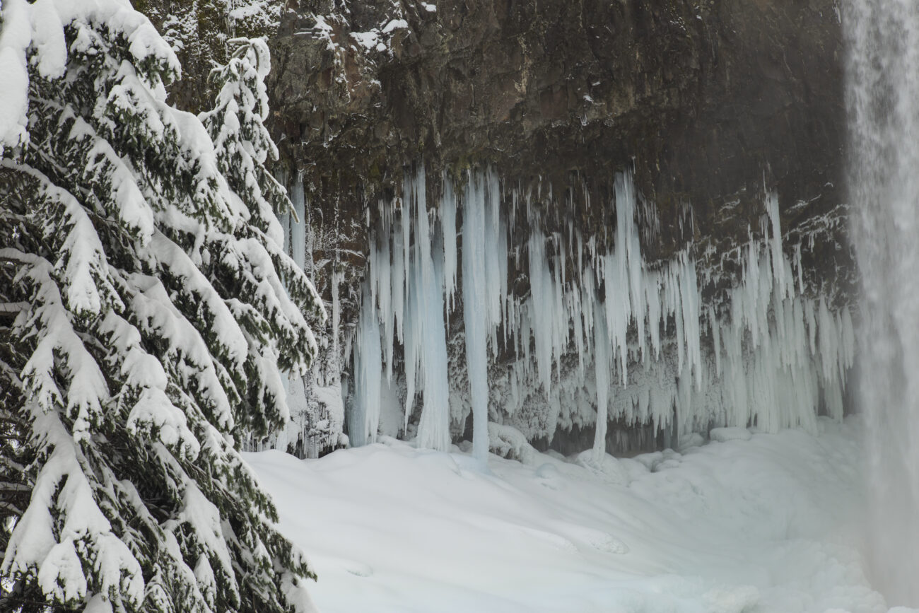
Passing the obstructions, there is less than 1/4th of a mile left to reach the fall, most of which involves traversing the side of a steep hill. After walking around this ridge, the 100′ high falls pop into view and it’s just a short couple of turns down to stand beneath them, well, near them.
Depending on the conditions when you arrive expect everything from waves of mist and water splashing around to frozen icicles and snow covered cliffs. Even standing back to avoid the icy river that forms in winter, the falls are thunderous and incredible but don’t take my word for it…

After you’ve had your fill of the falls, return the way you came with additional hiking options possible at the trail junction (consult your map for lengths and routes). Be extra cautious descending down to the boulders and in crossing through them of course but beyond that, just enjoy the trail and river as you wander on back.

Quick facts about the trail:
- Official Rating: Moderate (in winter)
- Start point: Marked TH on Highway 35 at milepost 72
- Distance: 4.0 miles R/T
- Duration: 2+ hours
- Climb: ~600′ effective climb
- Terrain: Packed to deep snow
- Crowds: Moderate to Busy
- Recommended time: Weekdays
- Facilities: None
- Parking: Large lot, subject to snow
- Permits: Recreation Pass / Oregon Sno-Park Pass (see signs)
Additional links: